Showing posts with label Maps. Show all posts

How to use your own icons in Google My Maps

This article shows how to use your own icons to label places in maps that you make with the My Maps' feature in  Google Maps.


My Maps is a tool provided by Google Maps that lets you make a map showing a specific collection of places.

Why is this helpful?   Well, you can search for a collection of places in regular Google Maps, and share the maps you can see - but if you do this, other people will see different places that are marked on the version of the maps that Google shows them, not the same as the places that are marked for you.    To guarantee what set of places other people see, you need to make a map in My Maps, and then you can share this specific map.

My Maps provides a standard set of icons that can be used for labelling places - and these days it's a pretty impressive standard set.   But it still doesn't include numbers, letters or other labels - and the icons provided may not be styled the way you would like.

Luckily Google have provided a way for you to use any icon to label points on a map you make.


How to use your own custom icon in a My Maps map

Make your map, and add the place(s) you would like to attach a custom icon to.

In the bar on the left hand side, hover your mouse over a place-marker which you want to assign a specific icon to.   

The line for that item will highlight slightly, and a small colour / paint-tipping icon appear will to the right of the place description, like this:


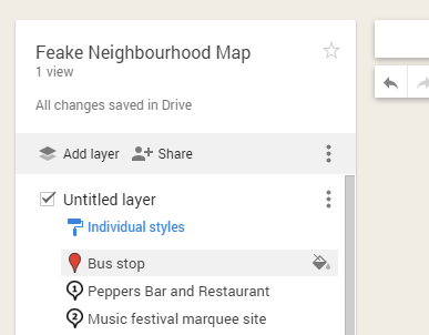
Click on the paint-tipping / colour icon

This opens a small hover-window, where you can choose the colour or icon shape.


Click the button at the bottom labelled More Icons.

On the pop-up that opens, you are able to select an icon from one of the categories available (currently Business, Crisis, Facilities and services, Points of interest, Recreational Activities, Transport, and  Weather).   Don't select any of these.


Instead, at the bottom of the screen, enter in the URL (ie website address) of a  file that you want to use as a marker.  (.jpg  .png  .bmp, and .gif   files can all be used).

Click Add Icon.

This adds the picture that you linked to the list of items available under Custom Icons, and selects it.


Click Ok to apply this icon to the point-marker that is being edited.


Job done!   Your map now has a marker that is made from your own image.


Things to be aware of / Troubleshooting

  • You need to load the image file to a file-host which handles picture files yourself:   there is no option to load a file directly from the More Icons tab.
  • The image file needs to stay, unchanged, in the place where you linked to - and that place has to be available to anyone who might look at the map: if you are sharing the map with "anyone in the world" then the markers need to be available like that, too.
  • The image file should be small to speed up loading time:   images in the set of markers I use are approx 2k each.
  • Markers will be displayed in the same small size as Google's markers, ie 32x32 pixels:   there's no point using a large, detailed photograph if it will shrunk down to so tiny that the details can't be seen.
  • You must provide the actual URL of the picture you want to use as a marker, not the Google Photos shareable link.   (Because the latter includes more than just the photo).
  • I don't know any way to bulk-load many custom icons into a My Maps map at the same time.   (There was a way to do this in the old Google Custom Maps, but this doesn't work in My Maps.)    Or to make one icon available to many / all your your My Maps at once.   If you have a solution for this, please leave a comment below.
  • If you your icon background to be transparent, then you need to create it in RGB colour mode: Icons with a transparent background created in Indexed colour mode don't work.


Related Articles

File hosts:  places used to store pictures used in Blogger

Hosting pictures outside of Google Photos / Picasa Web Albums

How to get shareable links to Google Photos

Finding the co-ordinates of a place in the new Google Maps

This article explains how to get the co-ordinates for a particular location in the new and old Google Maps interfaces.


New vs old Google Maps

In mid 2013, Google started rolling out a new version of Google Maps, which even now (Nov 2013) is still in Beta-testing and only works with Chrome and Firefox on desktop (ie not mobile) devices.  It's related to Google Maps Engine Lite - a better tool for creating custom map - not not exactly the same product.

When I looked at Maps Engine Lite, one of the things I noticed is that there are a number of features which are missing from the new tool- and the lack of a right-click feature on map-positions means that lots of functions are accessed in a different, possibly non-intuitive, way.


How to find the co-ordinates of a particular place in the new Google Maps


Left click on the exact place that you want co-ordinates for.


Notice that there is a small circle which radiates at that place, or the nearest on-street place.   It's a little this, except that it a white/light shade, rather than grey:


In the top left of the map, a small display box appears, showing the nearest street address and a pair of latitude / longitude co-ordinates.


For both the street-address and the co-ordinates:
  • You can copy / paste these as text.
  • If you hover your mouse over them, then inside the maps a small circle radiates out from that spot.
  • They are links: if you click on them, then the map zooms and centres at that place, with a large red marker and the street-address name or co-ordinates displayed beside it.
Note that if the place you originally clicked on is an on-street address, then the address and and co-ordinates will point to the same place. But they are not necessarily the same. (I think this is a mistake on Google's part: if they show an address with co-ordinates immediately under it, most people will assume that the two relate to the same place, but that's not true at the moment. It may change soon-enough though.)


How to find the co-ordinates of a particular place in the existing Google Maps


Right click on the location that you want to find the co-ordiantes for.


Choose "What's here" from the pop-up menu.


At this point, Google Maps will:
  • Show the latitude and longitude co-ordinates in the maps search box
  • Put a green arrow showing the exact location that you clicked into the map itself
  • Put the street address on the nearest on-street location into the maps search-result list, along with a marker to this location on the maps.


So of course you can copy-and-paste the co-ordinates from the search box.


(The pictures in this article above barely look like maps because I'm led to believe that one of the Terms and Conditons for Google Maps is that we cannot put screenshots of the mapping data into how-to articles. So I've kept the places particularly zoomed-in, to avoid any distinguishing features.)


Related Articles:

How to embed a Google custom map into your blog or website

Google Maps Engine Lite - a better tool for creating custom maps

How to access your Google Custom Maps after migrating to the new Google Maps

This QuickTip is about how to access your existing Google Custom Maps, once you have started using the new Google Maps interface being introduced in mid 2013.


quick-tips logo
Google is now offering the opportunity to migrate to new Google maps.  (ref: http://googlesystem.blogspot.com/2013/05/the-new-google-maps-now-available.html)

However one disadvantage is that "My Places", which includes Google Custom Maps, is not part of the new Google Maps interface.

At the moment, you can temporarily switch to the old interface by clicking the "options" icon in the black navigation bar and
  • Selecting "My Places" OR
  • Clicking the "classic maps" link.

Or you can get to them by navigating to https://www.google.com/maps/myplaces

From here you can see and edit your existing Google Custom Maps, but you cannot create new ones. To do that, you need to use Google Maps Engine Lite - which was announced recently.

Introducing Maps Engine Lite - a better tool for customizing maps

This article is an introduction to Google's Maps Engine Lite, which is a tool for creating custom maps.


What is Google Maps Engine Lite

In late March 2013, Google announced a beta (ie late-stage test) of Maps Engine Lite - and now it is available from the main Google Maps interface, without the word "beta" in sight.

This is a web application to let you "Create powerful custom maps", and it has more features than the current  "My Maps" custom-map editor in Google Maps, which I've used until now to put certain maps into one of my blogs.

You can access it at: https://mapsengine.google.com/

Once you have signed in to a Google account, you can either view/edit an existing map that you have make with Maps Engine Lite or which has been shared with you in MEL, or create a new one.


How to create a custom map using Maps Engine Lite

Click on the New Map button from the front screen, or the New map link from the manage-files folder (top left side of the screen).

Use the arrow beside Base Map to choose the style that you want applied: this covers both what is shown, and the colour scheme. At the moment the options are:
  • Map (ie ordinary - like regular Google maps)
  • Satellite
  • Terrain
  • Light Political
  • Mono City
  • Simple Atlas
  • Light Landmass
  • Dark Landmass
  • Whitewater


Add places to the map by:

Drawing them - You add things to the map with the Placemark and line or shape-drawing tools.  These are similar to those for Google Custom Maps, though they're now separate into two items.

or

Importing them - from either CSV/Excel files or you existing Google Custom Maps - see http://support.google.com/mapsengine/?p=lite_addplaces for details about what is possible.


You can separate the map into multiple layers, and you have access to Google Maps regular search feature: search-results are placed on non-permanent "search" layer, and you can select a result, right click on it and Save it to the map you are currently editing.


While editing the map, you have these options
  • Style - lets you choose whether to show individual markers, or a sequence of letters/colours
  • Table - Edit the list of placemarkers and lines - giving each a name or description
  • Labels - lets you choose whether to show marker labels on the map or not - and whether to use the name or description field.


Sharing maps you have made

The map can be shared using the green Share button in the top right corner, via gmail, G+, Facebook, Twitter or anything else which lets you use a link like this:


Putting Custom Maps on your website or blog

In Maps Engine Lite, the "embed on my website" option is available under the Save icon (currently at the top left, with options New map, Open and  Embed).  

However it only works if you have first clicked the green Share button, and set the map-visibility to Public (ie not just "anyone with the link").

This gives you a simple iframe statement like this:
<iframe height="480" src="http://mapsengine.google.com/map/view?mid=zV9FBQ3J7L1o.kzRGlAso0tmU" width="640"></iframe>
You can easily change the size via the height and width options, but there is no zoom level option - and I assume that the centre of the displayed map is represented in the coding  (this doesn't always work so well for Custom Maps - I usually recommend that people use the customization option).

And once you have the code, you can put it into your blog in the same way you would add any other 3rd party HTML.   The code above gives a map like this:


Notice that the map itself tells you that it was made with Maps Engine, and that it says it is for non-commercial use:   commercial users can buy access to a far more powerful version of the Maps Engine.


Advantages and disadvantages of Maps Engine Lite


So far I've only done a quick test, but initial impressions are:

Advantages:

Richer interface than custom maps - you can do more things.

Layers are a particularly good addition - it would be great if individual layers could be turned on/off from embedded version of the map.

Alternative colour scheme - will make it easier to create maps that are more suitable for certain circumstances, eg with a faded background.

Sequential markers - I don't have to use my own set of custom markers any more.

Uses the same base data as regular Google Maps - so the Follow Your World service can be used to get you updates about changes to the image-data.


Disadvantages:

No access to Google Streetview while you are editing the map.

Currently if you choose sequential markers, the labels and colours in the key on the left are not always the same as the ones used inside the map.

No Snap-to-roads option for lines

No custom map markers:  if you import a map from My Maps (aka Google Custom Maps), then any custom markers that you have are retained, and you can choose to use them again, but there is no way to add new custom markers.


What else have you found?


Related Articles:


Creating a Google Custom Map

Adding a Google Custom Map to your blog

Adding 3rd party HTML to your blog